NEW YORK – As a powerful winter storm moves out of the Northeast, its effects are still being felt across major cities and transportation hubs, with widespread travel disruptions and thousands of customers left without electricity on Sunday. Snow and ice created difficult conditions for air travel, leading to long delays and numerous cancellations at some of the region’s busiest airports. Travelers at Newark Liberty International Airport in New Jersey, along with John F. Kennedy International Airport and LaGuardia Airport in New York, faced delays exceeding two hours as crews worked to clear runways and aircraft amid ongoing winter weather.
Beyond transportation issues, the storm also caused notable power outages throughout the region. Tens of thousands of residents were impacted, with nearly 15,000 customers without electricity in Pennsylvania and roughly 14,700 outages reported in New Jersey. New York saw about 4,000 outages, while Ohio reported approximately 7,400 customers without power. Utility crews across multiple states were dispatched to restore service as conditions allowed, though continued snowfall and cold temperatures slowed progress in some areas.
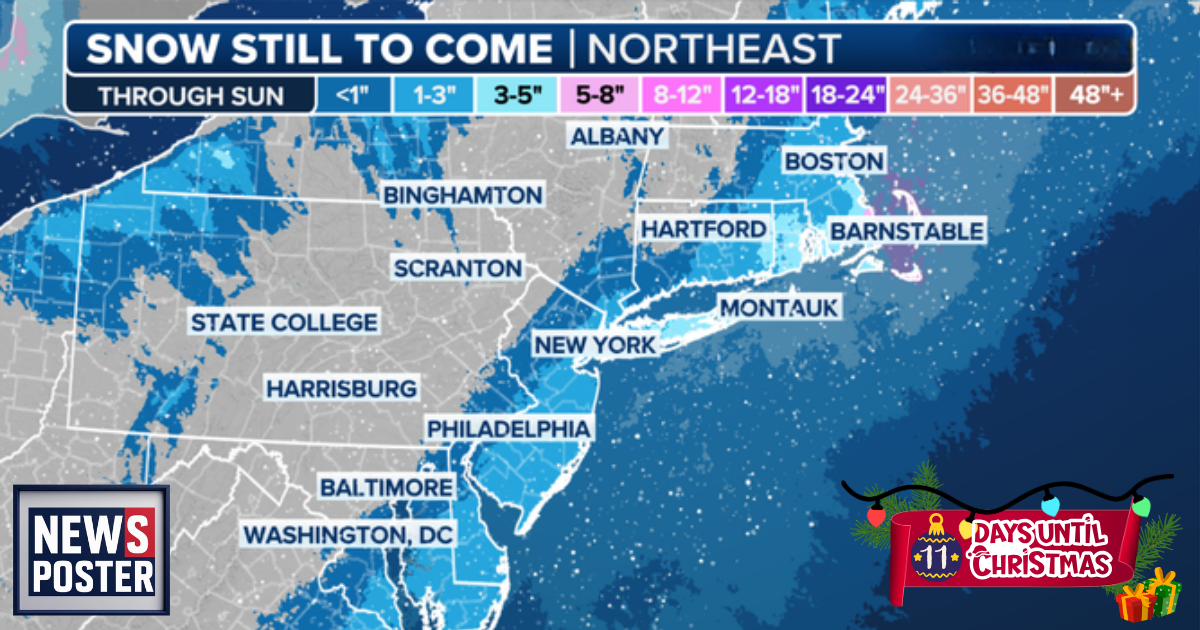
Weather alerts remained in effect across much of the Northeast. A Winter Storm Warning was issued for the Philadelphia area, while Winter Weather Advisories extended across a broad stretch of the region, including New York City, Baltimore, and Washington, D.C. Forecasters warned that major metropolitan areas such as Philadelphia and New York City could see between 3 and 5 inches of snow, with higher totals possible in surrounding areas. Parts of New Jersey and Long Island were expected to receive up to half a foot of snowfall, adding to already slick roadways and hazardous travel conditions.
Advisories stretched from Maryland along the East Coast through Cape Cod, covering much of the Interstate 95 corridor. In these areas, snowfall totals of 1 to 3 inches were anticipated, though localized spots in South Jersey and eastern Long Island could see heavier amounts reaching 4 to 5 inches. Snow continued to fall in several states, including Connecticut, New York, Massachusetts, Pennsylvania, and Maryland, prolonging cleanup efforts and keeping road crews and emergency services on high alert.
Some locations had already recorded significant accumulations, with more than half a foot of snow reported in parts of New York and Pennsylvania. Farther north, states across the Northern Tier, including much of New England, experienced an unusually early and intense start to the snowy season. Meteorologists attributed the pattern to the position of the jet stream, which has allowed repeated surges of moisture into the region while also drawing colder Arctic air southward.
The combination of persistent cold temperatures and frequent storm systems has created ideal conditions for heavy snowfall not only in the Northeast but also across the Midwest. Parts of the Midwest have already recorded more than four times their average snowfall for this point in the season. South Bend, Indiana, for example, is running nearly two feet above normal, while Chicago is experiencing its snowiest start to winter in more than two decades, with over 17 inches recorded so far and the bulk of that snow falling in just over a week.