An arctic blast is sweeping across the United States just as meteorological winter begins, bringing below-freezing temperatures to more than 235 million Americans through the end of the week. Monday is expected to be the coldest day, with subzero readings forecast across Montana, the Dakotas, Wyoming, Minnesota, and Wisconsin. In northern Montana, wind chills could make it feel 20 to 30 degrees below zero, while cities such as Chicago, Milwaukee, and Des Moines may see morning temperatures in the single digits and remain below zero throughout the week. The frigid air is also expected to reach as far south as the lower Mississippi River Valley, potentially triggering minor ice events.
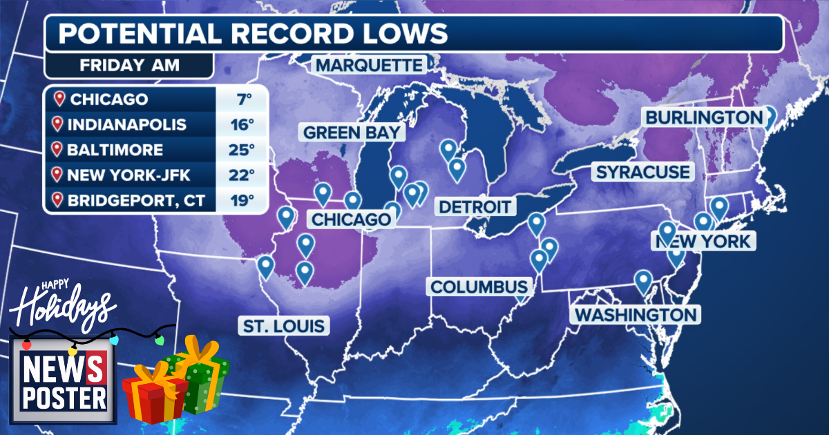
The cold surge moved south from Canada into the Mountain West over the weekend following a dip in the jet stream, spreading across the South and East. In addition to the arctic air, millions are contending with two powerful winter storms. A record-breaking storm over the Thanksgiving holiday dropped up to a foot of snow across the Midwest, while a second system traveling from Canada into the Rockies on Sunday will generate further snow as it moves eastward. The High Plains and Upper Midwest will continue to experience the coldest conditions through Tuesday and Wednesday. By Thursday and Friday, another arctic front will sweep through the nation, reinforcing freezing temperatures and setting the stage for potentially record-breaking morning lows. The Midwest is expected to see below-zero mornings on Thursday, with the cold expanding eastward by Friday to the I-95 corridor, affecting cities such as Pittsburgh, New York, Indianapolis, and Baltimore. Morning readings in the Midwest and Great Lakes are expected to be in the single digits, while the I-95 corridor could see temperatures in the upper teens to low 20s—conditions more typical of early February than December. NOAA’s Climate Prediction Center forecasts that cold and snowy weather will continue for much of the first half of the month, consistent with early-season forecasts tied to a weakened Polar Vortex and the La Niña climate pattern.